Wednesday, June 24, 2009

Bujumbura by Nicolas Clemesac

I would like to introduce you to the city of Bujumbura, the capital of Burundi.

Lying between hills and lake Tanganiyka, it is a small city where about 300 000 inhabitants live. From the rising sun to the night, it is full of life, people who walk to the market, taxi motos waiting for their clients, talking together, buses starting their trips to Uvira, on the other side of the lake, or to the « interior » of the country, full of people barely awake but ready for sinuous roads across the mountains.

Children around the buses carry baskets full of colours, cigarettes, sweets, bottles of water, selling to the travellers what they will need during their journeys, negotiating toughly with the drivers, who sometimes try to get free stuff from them.

Women, always the first in the streets in the morning, transporting all at once babies, goods to sell on the market, or going to the fields, several kilometers away, spades on their shoulders. They wear all colors of the rainbow on their clothes, forming a sweet kaleidoscope in the rising daylight.

All the sounds are mixed - laughs, shouts, klaxons, songs, they compose the music of the city, the best alarm clock ever made. Smells of fruits, vegetables, fish, exhaust pipes, the sweat of walking people are also mixed, swinging the heart between hell and heaven, like the broken roads which are winding through the city.

No big monuments in Bujumbura, apart from the cathedral, planted at the end of one of the main streets, its overgrowth as if its builders wanted to give evidence of the existence of God. No need to convince the inhabitants, who for some of them go to church twice or three times a day.

No monuments, except the presidential palace, kept by lazy soldiers, their Kalashnikovs like toys hanging on their backs. No monuments, except the inhabitants who are each of them full of history.

Sunday, June 08, 2008

'Ecomafia': the Rubbish Crisis in Naples, by Gery Ferrara

After a presentation in May 2008.

It is not easy to comprehend and to explain the true reasons for the rubbish crisis in Naples and in Italy.

Many different factors have contributed to the national shame of one of the most beautiful places in the world – with its stupendous bay and harbour, located between the Volcano of Vesuvio, the Amalfi coast and the marvellous islands of Capri and Ischia – converted into mountains of heaps of toxic and foul-smelling waste on fire in the streets as if after a nuclear explosion or during a revolution.

I have to tell you that my presentation will be a partisan one.

I am an Italian Prosecutor and I used to deal with just these kinds of crimes in Palermo where the hands of organised crime on the business of garbage disposal can be considered – if it is possible - stronger than in Naples.

I have directed a lot of investigations on environmental crimes committed inter alia by members of Mafia families. Most of them have been charged with the crime of illegal waste trafficking and arrested during the proceedings. Some of them are still on trial and others have already been convicted.

This preamble is necessary to underline once more that I cannot be neutral on this matter.

First of all I want to give you some numbers:

* Still today about 1,400 tonnes of rubbish are rotting on the streets of Naples and its suburbs after thousands of tonnes of rubbish – about 300,000 - has been cleared by the Italian army;
* 5 million eco-balls - unsorted compressed rubbish, in which toxic waste is often mixed with ordinary household refuse and the remains of old cars – are still waiting for their final disposal lying in thousands of acres of land in the landscape of Campania. The Region pays a huge amount of money for the rent of these areas;
* One and a half billion euros – you have understood right – has been spent in the last 11 years by the extraordinary chief for the so called emergency waste to solve the problem. Without any result.
* At least fifty calls are received every night by the Fire Department to put out the fires caused by the mountains of waste in the streets.
* Many investigations conducted by the Antimafia department of the local Office of the Prosecutor and trials are trying to ascertain what has happened in the last 10 years.
* Generally speaking, it has been estimated that the total amount of missing waste in Italy could be imagined as a new mountain 1,880 meters high with a base of 3 hectares. This ‘missing waste’ fuels a rich illegal economy. In 2006, earnings made by the illegal management of special (hazardous and non-hazardous) waste in Italy were estimated at almost 22.4 billion euros.
* Considering this huge amount of money it can be figured out why the Head of Cosa Nostra, Bernardo Provenzano, wrote in one of his famous “pizzini” (small notes that were used to communicate with the other members of the organization) which was intercepted during an investigation under the direction of the OTP in Palermo: trasi munnizza e nesci oro. (In comes waste, out goes gold)

In the area of Naples the rubbish crisis has been out of control for at least 15 years.

Since the beginning of the ‘90s, criminal organisations and other unscrupulous entrepreneurs ventured into illegal waste handling in the south of Italy and especially in Campania. A Highly lucrative market for illicit trafficking has emerged and expanded due to high profits and low, almost non-existent, risks under the direction of a violent, oligarchic system of controlling urban waste management.

It has been discovered that mafia–type organizations are the main intermediaries for contracts offered by local administrations. They not only bribe local authorities to get the contracts but also own the trucking firms, participate in building and managing garbage collection equipment, and manage legal disposal sites.

In Sicily, for example, the new strategy of Cosa Nostra (the so called strategy of “submersion”, or hidden strategy) pushed mafia-type organizations to increasingly invest in legal businesses, operating quietly without provoking social alarm: the watchword is ‘less blood, more business’.

Many investigations conducted in Southern Italy have illustrated that mafia-type organisations not only take care of the collection, transport, handling and storage of waste, but they also control legal dumps and are involved in clean-up activities promoted by public authorities.

In Campania, the oligarchic control of urban waste management has already been established and well developed by mafia-type organizations – the so called Camorra - due to the fact that special/hazardous waste management offers illegal entrepreneurs more opportunities for profit. The illegal handling of special and hazardous waste is much more lucrative than merely handling municipal waste.
Criminal groups exercising deep control over their territories have put their capabilities to work in the business and the considerable access to land, caves and manpower enjoyed by mafia-type organizations has caused large areas of that region to be transformed into illegal waste dumps.

A very effective word has come into use by experts, lawyers, investigators and magistrates: Ecomafia.

The Italian Dictionary defines Ecomafia as that Mafia sector which manages activities highly dangerous to the environment, such as the illegal building industry and the dumping of toxic and hazardous waste. Although the term Ecomafia may refer to activities of highly structured, hierarchically integrated criminal organizations, it is currently also used to refer to the more general phenomenon of environmental crime and the illegal exploitation and management of environmental resources and/or services.

Big business all over Italy has profited by paying the Camorra, local organised crime, at extremely low cost to dispose of their industrial waste by dumping it in the Naples area. The Camorra chose one of the most fertile and agriculturally profitable parts of Italy where it has absolute control of the territory.

Through the control of the territory and of the local, corrupted administration the Camorra succeeded in stopping the building of two new incinerator plants and in opening new landfill sites. Suburbs where the authorities are trying to open or reopen other dumps look like war zones, with barricades of overturned rubbish bins, corrugated iron and tyres, manned by menacing young men.

Nevertheless, the protests are not only founded on the fear of health damages. Often they are inspired by the economic interests of organised crime to dump illegally the huge amount of waste.

The crisis is blamed on overflowing landfill sites controlled by the Camorra which has sabotaged incinerator projects, thus poisoning the environment through untreated waste to the point where some forms of cancer in the region are three times the national average.

This is one side: the strength of organised crime and its links with corrupted administrators.
But incineration cannot be the sole solution, it neither disposes of the waste, nor does it remove the health hazards. It creates toxic dust and ash and risks attacking people's health in another way.

The other side is the liabilities of the population and the inefficiencies of the local and national administrations. Do not forget that the waste recycling in the south of Italy has the lowest rate in the whole of Europe and one of the lowest of the so called developed world.

In January the Italian government appointed a Naples' "rubbish tsar", the former Chief of Italy’s National Police Giovanni Di Gennaro. But he made very limited progress.

He decided to stop the reopening of old landfills and created some new temporary storage facilities for waste. Besides, he has understood that it is cheaper and more efficient to cart away Naples' waste by ship rather than by freight train to Germany as it was done until a few months ago.

But it is not enough. “Naples is still creating rubbish faster than it can dispose of it" he is used to repeating.

At the same time the European Commission started an enquiry to take court action against Italy which could lead to heavy fines.

The Italian plan appears unsatisfactory. It is still missing a clear indication of sites for treating waste and nothing has been planned for sorting rubbish. The implication of organised crime must not conceal the most direct cause - an absence of action and an absence of political will.

Finally, the “waste emergency” has been revealed as a massive and huge fraud against the local communities and the honest citizens who pay – it seems unbelievable – the highest waste tax in Italy.

The illegal bargains of this fraud-fattened hush-money - local politicians, criminals, entrepreneurs, including some big names of Italian industry such as the Impregilo of the FIAT group, who has recently been charged for non-compliance with contracts signed for the management and disposal of waste in Campania.

Sunday, April 06, 2008

Pilates, by Inmaculada Caballero Gomez

After a presentation on 1 April 2008.

THE PILATES METHOD

I heard about the Pilates method some years ago. At that time I felt very stressed and I used to suffer from backache so I decided to start doing some activity to improve my health. A friend of mine told me about the Pilates method and I took it up shortly after. I have been practising it for three years .

Now, I feel wonderful. The more you practise Pilates, the better you feel.

I would like to tell you something about it and I encourage you to practise it.

WHAT IS PILATES?
Pilates is a physical fitness system developed by Joseph Pilates. This method links mind and body based on the principles of Pilates: centering, concentration, control, precision, breath and flow. Pilates called his work “contrology”.

The Pilates Method was born during the World War I when Joseph Pilates was made prisoner in a concentration camp and he began to rehabilitate the injured German soldiers, putting his own concept into practice. As a result of this experience, he designed his special exercise machines named Cadillac and Reformer. He used them to development Pilates’ method.

BASIC PRINCIPLES:
1.- CENTERING: All energy for Pilates exercises begins from the “powerhouse”. It is the centre of the body encompassing the abdomen, lower back, hip, pelvis and pubic bones. From there the energy flows outward to the extremities.
It is very important to build a strong powerhouse because you have to coordinate all movements from the “core”.

2.- CONCENTRATION: The central aim of Pilates is create a fusion of mind and body; for that you must learn to pay attention to your body while you do the movements coordinating them with breathing.

3.- CONTROL: You have to keep control of your centre and all your body to prevent injuries and produce positive results.

4.- PRECISION: There is an appropriate position. Your body has to be perfectly aligned.

5.- BREATH: Breathing is very important in Pilates. It should be done with concentration, control, precision, coordination with movements.

6.- FLOW: Pilates exercises are done in a flowing manner: not effort, but fluidity and ease.

WHO AND HOW PILATES?
A wide range of people can practise Pilates: seniors, pregnant women, people who are at various stages of physical rehabilitation.

Pilates can be practised on a gym mat, exercises performed on the floor or with special machines invented by Joseph Pilates.

BENEFITS OF PILATES
If you practise Pilates, you will improve your flexibility, agility, elasticity, you learn to breathe properly, which reduces your stress.

Practising Pilates, you will correct your spine and your posture; you will strengthen your muscles, especially abdominal muscles and your pelvic floor. It can even help alleviate back pain and prevent injuries.

Pilates said: ” If your spine is not flexible at thirty, you are old; if your spine is flexible at sixty, you are young.”

Inmaculada Caballero Gomez

For more on the Pilates method, see The Pilates Foundation.

Sunday, November 18, 2007

Burkina Faso, by Celestine Yerbanga

Burkina Faso, formerly Upper-Volta, is a west-African country with an area of 274 000 km². It is a land-locked country surrounded by Benin, Ivory Coast, Ghana, Mali, Niger and Togo.

Created on 28th September 1919, Upper-Volta was a part of France's colonies and still has a preferred relationship with this country. On 5th September 1932, the colony of Upper-Volta was disbanded and geographically distributed to Mali, Niger and Ivory Coast. Reconstituted on the 4th September 1947, Upper-Volta became independent on 5th August 1960. With the 1983 revolution, the country was renamed on 4th August 1984 and Upper-Volta became Burkina Faso meaning "land of people of integrity".

With a population of 12 million inhabitants, Burkina Faso is one of the most populated countries in west-Africa. The inhabitants are mostly Muslims (52%) and Christians (17%). French is the official language but there are also more than sixty ethnic groups with their own languages. The climate is tropical and there are two seasons: the dry season (from November to May) and the wet season (from June to October).

The main cities are Ouagadougou (the politic capital), Bobo-Dioulasso (the economic and cultural capital), Koudougou (known for its textile industry), Ouahigouya, Fada N'Gourma and Banfora (the industrial city with sugar cane plantations, a factory and a flourmill). Ouagadougou, "Ouaga" to the locals, is also called “capitale des deux roues” because bikes and motorbikes constitute the main mode of transport. In a certain way, Ouagadougou can be compared to China.

Burkina Faso is a land-locked country, and almost all its import-export business relies on the sea ports of border countries. Until recently, Burkina Faso had a special relationship with Ivory Coast: nearly all the goods bound for Burkina Faso, used to pass through the sea port of Abidjan (Ivory Coast). In addition, the railway linking Abidjan to Ouagadougou was an important route of freight transport. But with the latest political troubles in Ivory Coast, borders were locked and neither transport by road or rail was possible. Consequently, Burkina Faso was forced to turn towards the sea ports of Togo and Ghana.

Tourism is being developed. In the north, it is amazing to discover nomadic people’s way of life and visit historic and archaeological sites as well as beautiful sand dunes in a Saharan landscape. On the contrary in the west, the vegetation is quite luxuriant. Falls can be found in some places.

This area is famous for its National culture week with music, dance, mask and theater. In the east, there are wildlife parks and shooting is very popular. Ranches like “Nazinga“ are well-known to tourists. As to the south, the emphasis is put on house decoration, a traditionally female activity. On the international scene, the centre is well-know through major events such as the International art and handicrafts trade show of Ouagadougou and the Panafrican film and television festival of Ouagadougou.

The Burkinabè (the inhabitants of Burkina Faso) are cheerful, friendly and whenever you decide to visit Burkina Faso, you will be warm-welcomed!

Wednesday, October 31, 2007

Briançon, by Florence Zaoui

The town of Briançon in the Alps is the highest town in France (1200 meters) and the second highest town in Europe (after Davos in Switzerland).

The billboard located at the entry of the town says that it is sunny 300 days a year. And it doesn’t lie.

Briançon is not so far from Italy (15km from the Italian border) and a lot of Italians go there or live there. Most of them speak French and those who don’t speak French can easily speak Italian with the inhabitants who learn this language at school, while students of the rest of the country learn English.

The inhabitants of Briançon also enjoy the proximity of Italy. They often go there to buy alcohol and cigarettes because they are cheaper. Moreover, they had special prices for the Olympic Games which took place in Torino last year. This amity between Italians and the inhabitants of Briançon is recent: the old part of Briançon was actually fortified by Vauban in order to prevent invasions from Italy.

In summer, you can go hiking around. The landscape is beautiful and you can, if you are lucky, cross a marmot or a chamois on your way. When I was a child, I used to play on the small spaces of snow which hadn’t yet melted. Now, because of global warming, it is rare to find snow in summer.

In winter, you can go skiing, whether you are a beginner or experienced. You can also enjoy the terraces of the cafés on the ski runs because they are always sunny.

Finally, if you are addicted to skiing as I am, you can ski by night on some opened ski runs and enjoy the view of the city.

North and South Korea: the DMZ, by Sangyep Song

The Korean DMZ : A Symbol from Death to Life

The Korean Demilitarized Zone was created as the result of the armistice agreement in 1953 after the 3 year-long Korean War which took place from 1950 to 1953.

For its initial purpose as the buffer zone between the South and North Koreas, the DMZ has been evacuated since 1953. No inhabitant, no human activity has been allowed in the DMZ.

For more than 50 years, it has been a deserted land. For example, soldiers from both sides have not been able to exhume the bodies of old combat comrades in the DMZ to avoid any unintentional appearance of hostility.

Fully armed with anti-personnel and anti-tank mines, the DMZ has been the land of death. At least more than a dozen times per year, North Korean solders have fired against the South which the South has reported to the UN Security Council as violation of the armistice agreement. However, those hostile acts continue to happen in the DMZ as of now.

I still remember the shivering memory of staying overnight in the DMZ for a reconnaissance mission as a part of my officer training program in 1995. Absolute silence filled with blood-pumping tension overwhelmed me that night.

From the 1990’s, the South Korean President adopted the so-called “Sunshine Policy” which takes its name from Aesop’s tale, i.e. the tale of how the sun could take off the traveller’s coat. Instead of an eye-to-eye policy in treating the North’s hostility, the South tried to show trust to North by providing aid.

Despite the skepticism against the Sunshine policy, there has been a series of visible consequences between the two Koreas.

The recent visit of the South President to Pyoung -Yang, the capital of North Korea, is the epitome of those consequences suggesting the improved relationship of the two Koreas. It was a historic moment when the South Korean President could step on the Military Demarcation Line in DMZ while North Korean soldiers guarded ‘the enemy target No. 1’, the President of South Korea..

The sensation was doubled by the dark historical impression of the land of death “DMZ”. The DMZ now becomes the birthplace of new hope between the two Koreas.

Not only as the birthplace of hope, the DMZ now becomes famous for the birthplace of rare and endangered species. As no human activity has been carried out for more than 50 years, the DMZ has become a paradise for wild animals and plants.

The citizens of Seoul are eager to pay more money for the fruits and dairy products which were produced near the DMZ because of its cleanness from pollution.

Now the DMZ’s old image of the dead land is changing to the birthplace of Hope and Life.

Monday, May 28, 2007

Guadalupe by Gisele Catroux

In 1969, when I was born, I lived in Guadalupe for three years. It’s a very nice island located in the eastern Caribbean Sea at 16° 15' latitude north (the same as Thailand and Honduras) and longitude the same as Labrador and Malouines Islands. Guadalupe Island is composed of two distinct islands separated by an arm of the sea named “Salt River” but connected between them by two bridges.

Basse-Terre is the bigger (848 square kilometers), composed by the active volcano “The Soufriere” (1467 meters) (last eruption: 1976), located about ten kilometers north of Basse-Terre and on the west of Carbet Falls. Her surname is “Old Woman”. Her activity is special: sulfur vapors and hot water springs. It’s the only active volcano since ten thousand years.

Grande-Terre (588 square kilometers) is composed of an irregular succession of the ocean depths in the center and in the north, an arid shelf with rocky and wild coasts. On south littoral is located the largest tourist area, named “The Riviera”.

Four hundred twenty-two thousand people live in Guadalupe. The national language is Guadalupe Creole but every one talks in French. It’s an overseas department of France and also one of twenty-six regions of France.

It’s a very nice country with beautiful beaches and good drinking (ti’punch = rum with green lemon and cane sugar, lot of cocktails with tropical fruits), meals (curried lamb) and desserts (bananas flambé = bananas flambé with rum and cane sugar). The people are very friendly.

This country is my second country of birth.

Samoa by Faamoana Laufiso

Samoa, formerly called Western Samoa, is famed for its natural beauty and friendly people.

Originally settled by the Tonga polynesians, it was the European explorers and missionaries that transformed these islands for better or for worse. Christianity was introduced to the natives, and many local customs soon disappeared. At the conclusion of World War 1 and for the next 42 years, New Zealand occupied and administered the islands. Then in 1962, Samoa became the first Polynesian nation to re-established its independence in the 20th Century.

The large islands of Savaii and Upolu are mountainous (volcanic in origin), and covered with heavy forests. Both are ringed by coral reefs. The local population is mostly indigenous Samoans. The port city of Apia is the center of local government and trade, and the economy revolves around agriculture, lumber and tourism.

American Samoa, a neibouring group of islands, shares the same culture and much of thesame history. Samoa's population is approximately 180. 000 and the most populou full blooded polynesian race in the world. It is situated on the east of the international date line between longitudes 171 and 172 degrees west and latitude 13 and 14 degrees south of the equator.

Samoa has two seasons, the wet season from Novemer to March, and dry season from April to October. The average temperature is between20 and 30 degrees all year round.

Albania by Juela Misha

Albania is a Balkan country situated in South-Eastern Europe. It lies between Montenegro in the north, Kosovo in the northeast, Macedonia in the east, and Greece in the south.

Most of Albania consists of mountainous and hilly terrain (approximately 70% of the country), with deep and inhabited valleys. The western part of the country along the Adriatic and Ionian coast consists mainly of lowlands that contain nearly all of the country's agricultural land and is the most densely populated part of Albania.

It has a Mediterranean climate with not so cold winters and very hot summers.

98% of the population is ethnic Albanian and 2% are minorities. The official language is Albanian, with two main dialects, Gheg and Tosk. Some Greek is also spoken in the south.

The capital of Albania is Tirana and that is also my home city. Tirana is the centre of the political and cultural life of the country. It has a population of approximately 700,000 inhabitants.
Tirana is a vibrant city with a lot of pleasant bars and cafes, so at weekends you can go there, meet your friends and have a drink.

It also has a nice city centre with a big boulevard built during World War II by the Italians.
Most of Tirana consists of communist style buildings which were very ugly but most of them now have been painted in nice colors and look interesting.

On the outskirts there is a big park that is like a forest and has a big artificial lake in the centre. This is a very nice area to go for picnics, jogging or to get a breath of fresh air. But you can also go to the beach to cool off because fortunately Tirana is only a 30 minute drive from the sea.
All in all, although it has terrible traffic, Tirana for me is a nice place to live in.

Friday, June 09, 2006

Ecuador (Claudia Gonzalez)

After a presentation in June 2006. By Claudia Gonzalez.


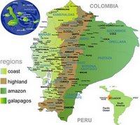
Ecuador is a small country situated in the northwest of South America. In the north it is bordered by Colombia, at South and East with Peru, and west the Pacific Ocean. The presence of the Andes Mountain range and the maritime currents have generated variation in the climate and because of that we have three significant geographic regions: Coast, Highland, Jungle and Galapagos Islands, each one with its own different micro climate. Ecuador has an area of 256.370 square kilometres and around 12.000.000 habitants.

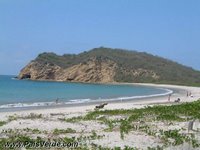
The coast is characterized by the beautiful beaches and the temperature of the water where every year the humpback whales come to mate. The weather is tropical- humid, the temperature is between 23 to 26 degrees and we have two seasons: a rainy season between December and May and a dry one from June to November. The people are open, they like to dance and have parties. They are also dedicated to agriculture of bananas, cacao, sugar cane, tropical fruits and especially to fish. They are specialists in delicious dishes with fish and coconut.

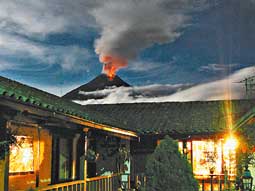
From the Coast to the Highlands you can travel around 10 hours by car and by aircraft is around 45 minutes. The Andes are characterized by impressive volcanoes, snow-capped peaks and lakes. The most impressive are the volcanoes Cotopaxi with 5911 m. and Chimborazo with 6310 m. The weather is dry between May and October and in the rainy and cold season between November to April, the temperature is between 13 to 24 degrees Celsius.

The Central highlands of the Andes were the seat of the Inca Empire. It stretched from the south of Colombia to the north. with the name “Tahuantinsuyo”. The Incas were a vast population of dozens of different ethnic groups with their own languages, customs and economies based on cultivation of the land. With the arrival of the Spanish in “Tahuantinsuyo”, Atahualpa “the Indian cacique” (the Indian king) was taken prisoner and this started heavy fighting between the Spanish and the Incas, who resisted being conquest.

For the Spanish, America represented a land full of riches, taken in the name of the Crown and they conquered the natives in a bloody manner. The Spanish used a variety of strategies, among which was indoctrination and the use of rival Indian chiefs.

Several different indigenous nationalities continue to live in their traditional lifestyles in rural villages and towns throughout the nation. In the cities, you find many mestizos, African Ecuadorians, and whites. The people are dedicated to agriculture of corn, potatoes, all kind of vegetables and fruits, flowers and breeding of animals. The typical food is potato tortilla, roast pork and chicha (maize-based alcoholic drink).

The Capital Quito is situated in an Andean valley at 2,850m above sea level at the foot of Volcano Pichincha (4,794m). Quito has been declared a Cultural Heritage of Humanity site by UNESCO for its architectural beauty, home of the numerous churches and convents built in the colonial period.

From Quito to the jungle, commonly know as the Amazon basin, you can travel around 8 hours by car or by aircraft around 40 minutes. This area is characterized by a lot of fast-flowing rivers, heavy rain and hot-humid weather, the temperature is between 23 and 36 degrees Celsius. The rainy season is between January and September and the dry one is between October and December.

The indigenous tribes in the Amazon are Quichuas, Shuar, Achuar, Siona, Secoya, Cofan, Zaparo, and Huaorani, who don’t like to have contact with modern civilization. Each group speaks its own language.

The Jungle has an extended variety of trees, flowers, orchids, medicinal plants and a great variety of mammals and reptiles as pink dolphins and caimans. The Amazonian dishes are base of yucca, Capibara meat, saino, turtle, guanta crocodile meat and boa meat, Fish such as peiche, catfish, bocachico, and piranha are also very popular.

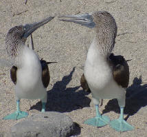
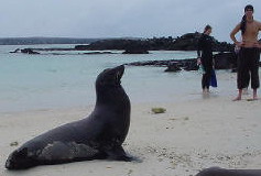
The Galapagos Islands are situated a thousand kilometres off the coast of Ecuador. This archipelago has 125 islands and 5 of them are habitable and barren islands of volcanic origin which are about 3 to 5 million years old. The famous naturalist Charles Darwin found a sustained theory of the evolution and the origin of the species.

The Galapagos have a temperate climate. The temperature is between 22 to 32 degrees Celsius and is considered a natural reserve where the animals live in a natural environment near to humans. In certain areas it is possible to partake in both, deep or shallow diving and have contact with the aquatic species of the sea: coral reefs, whales, whale sharks, hammer head sharks, sting rays, manta rays, sword fish, turtles, sea lions.

Ecuador is a small paradise rich in natural resources, but due to the management of politics and the economy it is a poor country.